On my first full day here I had a curious compulsion to visit Cambridge (can't think why). There I sat on a lawn chair in a Harvard courtyard, reading, occasionally looking up from my book to wonder whether the people around me were visitors, locals on their lunch hours, academics, graduate students, summer school attendees, or none of the above, and whether there were any solo travellers across the Atlantic, in the other Cambridge, sitting on lawns in university courtyards, wondering the same thing.
But since I am now in a city where the heat is a little drier and breezier, there has been at least as much walking as there has sitting. And this has necessitated some map usage, which feels like a particularly significant topic of discussion just now because I have very recently made the transition from using old-fashioned paper maps to newfangled digital ones.
As some of you may know, I was stubbornly attached for several happy years to a dirt cheap Nokia that just about knew how to call, text, tell the time and convert pounds to euros, and which suited my humble needs perfectly. Last month I begrudgingly gave in to smartphone culture after some fairly persuasive arguments from my parents (one of them being to buy me a smartphone), and now I have a thin black boxful of information with me wherever I go. One such informational function is, of course, Google Maps, which has been put to frequent and active use. Previously, my first acquisition on arriving in a new city would have been a map, but now I have no real need for one. All my cartographic needs are supposedly taken care of by the oblong in my pocket. And yet they aren't - not quite.
Google Maps certainly has its advantages. A paper map immediately singles one out as a stranger, a foreigner, or - worst of all - a tourist, rarely a desirable thing and sometimes an unwise one. Checking my phone as I walk down the street, however, I could be any old local; no one need know what I am doing. The scope of the map is also potentially much broader when it is digital. No corner of the city is too far-flung - nor indeed is any corner of anywhere. If I wish to peruse Beijing from above while wandering around Boston, that is no issue. I can zoom out of Boston, out of Massachusetts and out of America; I can abstract myself from the surface of the map until I am floating in space; I can skim in any direction I desire over the country and over the world.
But while it can, if I want it to, show me the broadness and the connectedness of everything, most of the time it just shows fragments. It shows what fits onto its small, oblong screen, which, if I want to see my surroundings in any detail, is not very much. Only with difficulty can it show me how the pieces of the city fit together and work together, how individual streets and neighbourhoods slot into the bigger picture. It doesn't tell me how Medford relates to Somerville and Cambridge or how all three fit with central Boston or Jamaica Plain.
Worse, it is disabling my internal compass. No longer an anonymous map reader of unmarked whereabouts, I now have a presence on the map itself in the form of the little blue arrow that walks when I walk, turns when I turn, hesitates when I hesitate. And this little blue arrow has become my main concern. I have stopped judging my whereabouts by looking at street names and landmarks and started slavishly following the arrow, even when it is wrong. I am blinkered to the things that lie outside the arrow's chosen path. I no longer dive down streets because they look interesting, with no concern for where they might take me. I know exactly where my cartographic alter-ego is at all times, but I don't know much about where I am any more.
This makes me a bit sad. I feel I have lost something. Stopping to look at the map is no longer an indulgence to be savoured; I feel guilty, as if I'm cheating. The map is just another smartphone function, a distraction that removes me from my surroundings precisely when I most want to engage with them.
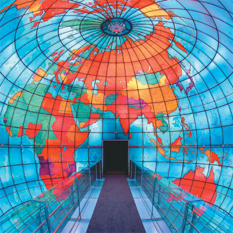
And so yesterday, to counterbalance this woeful state of affairs, I visited every cartophile's dream place: the Mapparium at the Mary Baker Eddy library. Mary B.E. was the founder of the Christian Science movement, and the Mapparium was built to symbolise the movement's far-reaching, international significance (although those of us with atheist leanings can equally take it to symbolise the far-reaching, international significance of just about anything). It is a room with stained-glass walls that form a giant, inside-out globe. You go through a door, out onto a bridge, and you are STANDING INSIDE A MAP OF THE WORLD.
 |
| Source: thephoenix.com |
Today, I will appease my inner cartographer in a more everyday fashion. I will buy a map of Boston made of ink and folded paper.
No comments:
Post a Comment